The "Shrinking Palestine" Four-Panel Map
A widely circulated four-panel map purporting to show the loss of "Palestinian land" over time. The four panels are typically labeled:
"Palestine 1946"
Almost entirely green, labelled PALESTINE, with small white patches.
"UN Plan 1947"
Divided between green (PALESTINE) and white (Israel).
"1949–1967"
Green reduced to the West Bank and Gaza.
"Israel 2012"
Green fragmented into scattered enclaves.
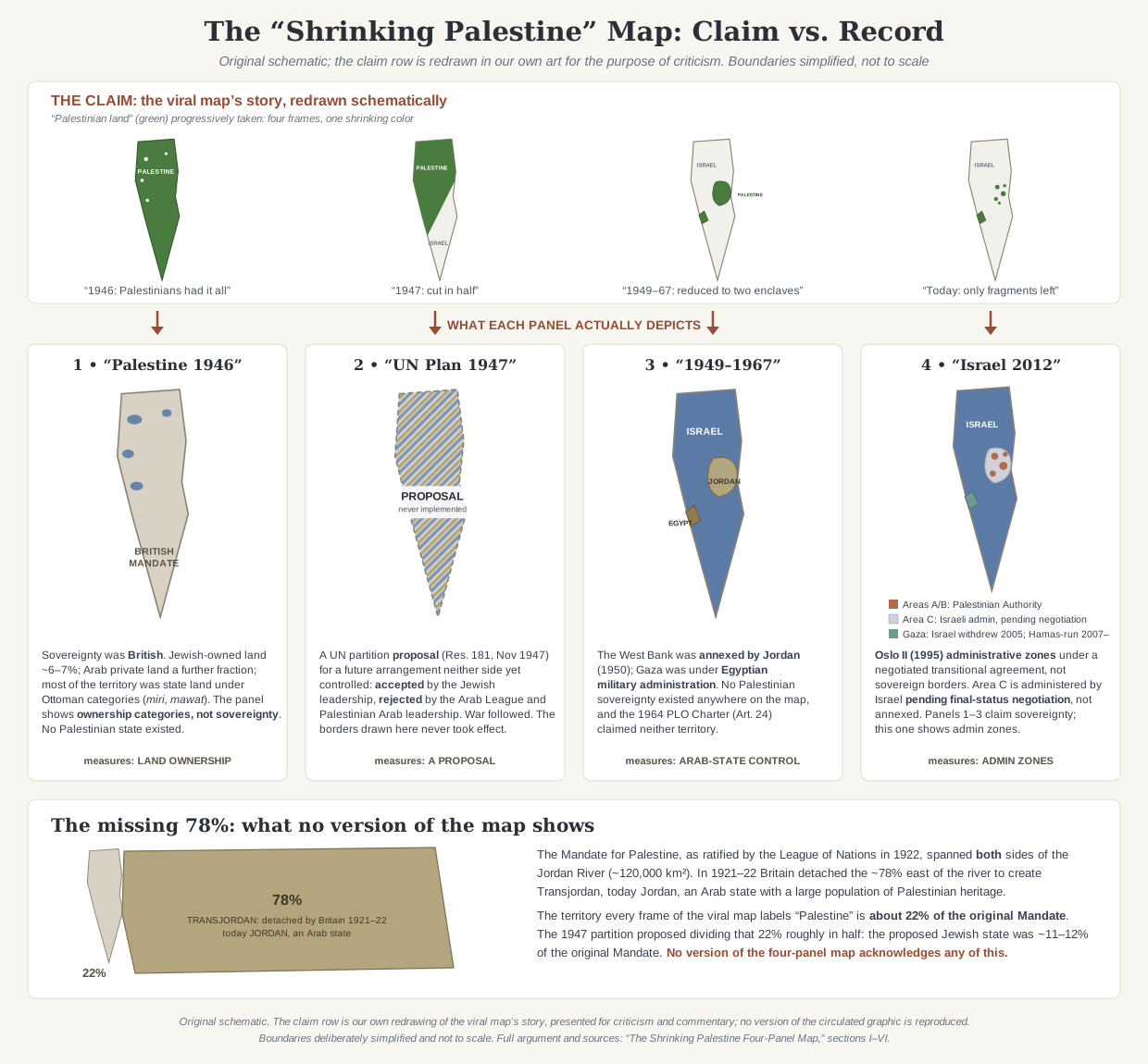
The implicit argumentLook at the maps. Palestinians once had everything; Israel has progressively stolen it all. Israel is a colonial expansionist project erasing Palestine.
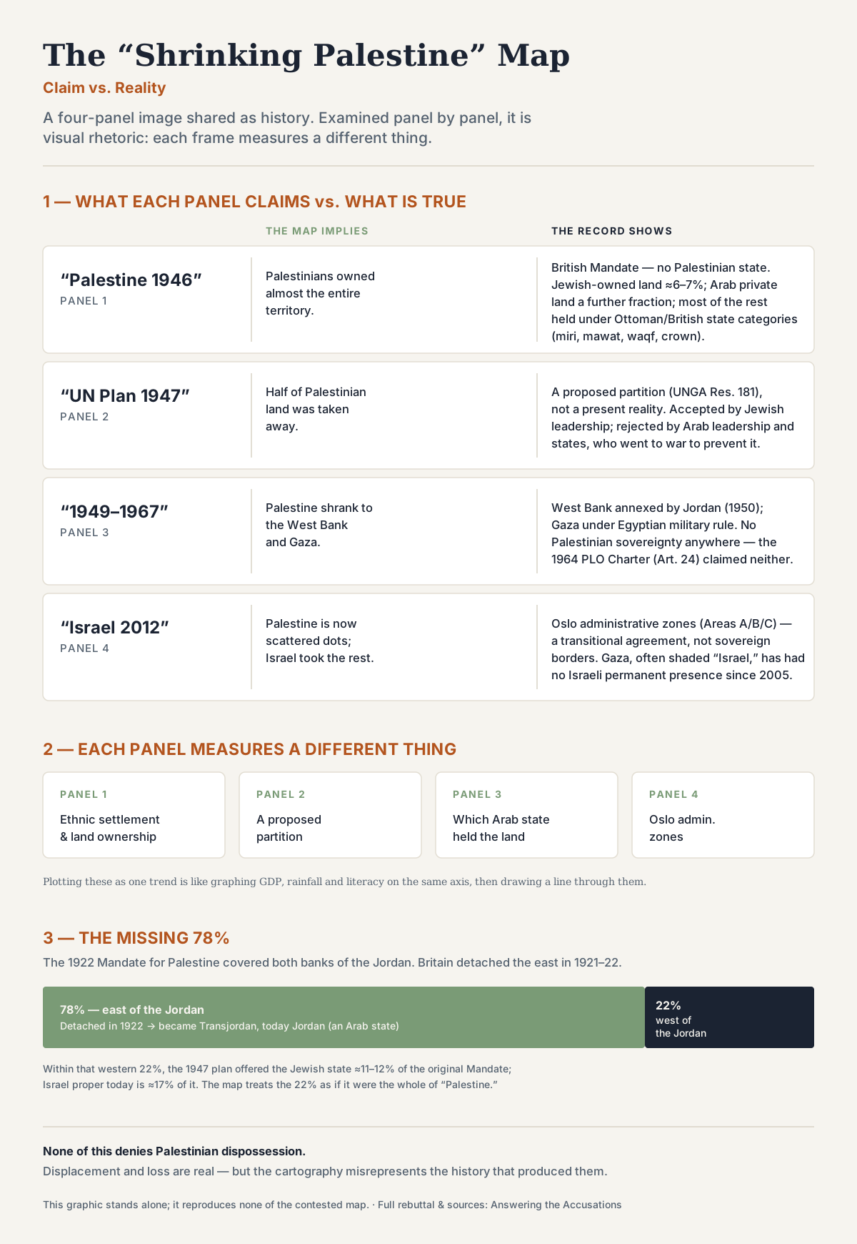
The map is not a historical record but a piece of visual rhetoric: each of its four panels measures something different (ethnic settlement, a proposed partition, foreign Arab occupation, administrative zones under a transitional agreement), the green-to-white progression implies a loss of sovereign Palestinian territory that never existed at any point in the sequence, and the entire frame omits the foundational fact that 78% of the original Mandate for Palestine was carved off in 1922 to become Transjordan, today Jordan, an Arab state with a majority-Palestinian population.
The map's power is that it appears to be data. Four panels, dates, a simple color progression; it looks like cartography, but it functions as rhetoric. Examined closely, every panel misrepresents what it claims to show.
The 1946 panel labels all of Mandatory Palestine "PALESTINE", but there was no Palestinian state in 1946. The territory was British-administered, and much of it was not privately owned by either Arabs or Jews but classified under Ottoman and British land categories including state, miri, and mawat land. The 1947 panel presents the UN partition proposal as if it depicted a current state of affairs; it didn't; it was a future arrangement neither side controlled, accepted by Jewish leaders and rejected by Palestinian Arab leadership and surrounding Arab states, with the conflict escalating into civil war and then interstate war in 1948. The 1949–1967 panel labels the West Bank and Gaza "PALESTINE", but during that period the West Bank was annexed by Jordan and Gaza was under Egyptian military administration; there was no Palestinian sovereignty anywhere on the map. The 2012 panel colors Areas A, B, and C as if they were three different categories (Palestinian territory, jointly administered territory, and Israeli sovereign territory) when in reality they are administrative zones under the Oslo Accords, a transitional agreement. Gaza, which the map typically shows as Israeli, has not had an Israeli civilian or permanent military presence since 2005 and has been governed internally by Hamas since 2007, though its broader legal status remains internationally disputed.
Beneath these panel-by-panel problems sits a larger one. The Mandate for Palestine, as ratified by the League of Nations in 1922, originally covered the territory on both sides of the Jordan River, roughly 120,000 km². In 1921–22 the British detached the territory east of the Jordan to create the Emirate of Transjordan, today Jordan, an Arab state. The territory the map labels "Palestine" represents about 22% of the original Mandate. The remaining 78% is an Arab state with a substantial population of Palestinian heritage. None of the four panels acknowledges this. The frame the map establishes (that "Palestine" means the land west of the Jordan, and that this is being progressively taken) is itself a rhetorical construction, not a neutral starting point.
Examined closely, every panel misrepresents what it claims to show.
None of what follows minimizes the genuine experience of Palestinian dispossession: the displacement of 1948, the conditions of life in the West Bank and Gaza, the loss of homes, villages, and family ties. These are real and serious, and the map's persistence in circulation owes much to the fact that it speaks to a Palestinian experience of territorial fragmentation that is, in important ways, true. The argument here is narrower: the cartography misrepresents the territorial and legal history, and the political case the map implicitly makes, that Israel was built on stolen sovereign Palestinian land, is not what the historical record supports.
The summary infographic above consolidates this argument visually: what each panel claims, what each panel actually shows, and the missing 78%. The detailed analysis follows below.
Where this claim comes from
The four-panel "shrinking Palestine" map is not a single artefact but a family of versions in circulation since at least the 1990s, produced by various pro-Palestinian advocacy organizations. The version most widely shared today carries a watermark from the "Palestine Awareness Coalition," but functionally identical maps have been published by Students for Justice in Palestine chapters, Jewish Voice for Peace, and numerous activist sites.
The map's design is optimized for the medium in which it circulates. It requires no text. It produces an instant emotional response: green becoming white, fullness becoming emptiness. It is shareable as a single image. It can be deployed against any audience, in any language, without translation. These properties are not accidental: the map was constructed to be viral, and it succeeds.
The map reflects themes that also appear in post-1967 Soviet anti-Zionist discourse and in the academic settler-colonial scholarship that followed: Edward Said's The Question of Palestine (1979), Patrick Wolfe's theoretical work on settler colonialism in the 2000s, and the BDS movement's translation of that framework into activist visuals from 2005 onwards. We do not claim a direct genealogical line from any one of these to this specific map; we note that the map's central assumption, that there was a sovereign Palestinian territory which Israel progressively colonized, is the same assumption these intellectual currents share. The four-panel map format predates the Visualizing Palestine organization (founded 2012), with earlier versions in circulation by the 1990s; Visualizing Palestine produced its own widely-shared variant in 2015 28.
The map has been examined critically by a range of commentators. Among the published critiques: the Jewish Virtual Library has produced detailed panel-by-panel analyses; CAMERA (Committee for Accuracy in Middle East Reporting and Analysis) has documented the cartographic distortions; HonestReporting has set out similar arguments; the journalist Yair Rosenberg has written about the map's misrepresentations; and even some commentators sympathetic to the Palestinian cause have acknowledged the panel-2 and panel-3 errors as historically indefensible 242526. None of this has reduced the map's circulation, which speaks to its rhetorical effectiveness rather than its accuracy.
Detailed rebuttal
Panel 1, "Palestine 1946"
The 1946 panel is the foundation on which the whole map's argument rests. It shows the territory of Mandatory Palestine colored almost entirely green, labeled "PALESTINE," with small white patches scattered through it. The visual implication is that Palestinians "had" the entire territory except for a few Jewish enclaves.
Every element of this is misleading.
There was no state called Palestine in 1946. The territory was British Mandatory Palestine: a League of Nations mandate administered by Britain since 1920. Sovereignty rested with the Mandatory authority, not with any local population. Labeling the territory "PALESTINE" implies a Palestinian Arab state that did not exist.
The green is not "Palestinian-owned land." The color suggests private Arab ownership of the entire green area. The actual land-ownership picture in 1946 was more complex. Jewish-owned land was approximately 6–7% of the territory; privately owned Arab land was a further fraction (precise figures are debated but well under half); the remainder, the majority of the territory, was not privately owned by either side. It was classified under Ottoman and British land categories including miri (state-owned land held under customary tenure), mawat (uncultivated land treated as state property under the Ottoman Land Code of 1858), waqf (religious endowment land), and crown land under the British Mandate 657. Two important caveats: first, "state land" under Ottoman classification does not map cleanly onto the modern concept of sovereign public land; Palestinian Arab communities lived on and farmed much of it under customary arrangements. Second, the legal category of the land is not the same as the human reality of the people who used it. The point here is narrower: coloring the entire territory green and labeling it "Palestine" implies a unified pattern of Palestinian private ownership and sovereignty that does not match the actual land records.
The white patches misrepresent Jewish presence. The small white spots on the 1946 panel appear to represent Jewish settlement clusters, not the totality of Jewish-owned land. By visually compressing Jewish presence into a few dots, the map exaggerates Arab territorial holdings while minimizing Jewish ones. A map honestly depicting the 1946 land-ownership picture would show three categories (Jewish, Arab, state) not a binary of green and white.
The panel functions as a baseline against which all subsequent "loss" is measured. By misrepresenting that baseline, it predetermines the conclusion the rest of the map appears to demonstrate.
Panel 2, "UN Plan 1947"
The 1947 panel rests on a category confusion that fundamentally affects how the rest of the map reads. It shows the territory divided between green and white, but presents this proposed partition as if it depicted Palestinian Arab territory being reduced.
UN General Assembly Resolution 181 of 29 November 1947 was a proposal for the future of the Mandate, to take effect upon British withdrawal. At the moment the resolution passed, neither Jews nor Arabs controlled the territory the map shows them as holding: the British were still the Mandatory authority. The resolution proposed creating two states from a Mandate that had no prior partition between them 4.
There was no pre-existing Palestinian state to lose territory. The map shows a hypothetical future as if it were a present reality, then uses this fabricated baseline to imply that Palestinians "started with everything" and were forced to give up half.
Three additional facts the panel omits:
The Jewish leadership accepted the partition plan, despite its significant limitations: the proposed Jewish state included large Arab populations and the borders were strategically indefensible 16.
The Arab League rejected the plan categorically and announced it would use force to prevent implementation; Palestinian Arab leadership likewise rejected partition 3515.
The territorial outcome of the war that followed, the 1949 armistice lines, was the consequence of an Arab-initiated war to prevent partition, not of the partition itself. Had the Arab side accepted partition in 1947, the territorial map of the region would look entirely different, and there would have been a Palestinian Arab state for the past seventy-five years.
The 1947 panel erases all of this. It depicts a proposed division as a fait accompli imposed on Palestinians, with no agent and no choice.
Panel 3, "1949–1967"
The 1949–1967 panel is the most historically inaccurate of the four. It shows the West Bank and Gaza colored green and labeled "PALESTINE," with the remainder labeled "ISRAEL." But during the period it claims to depict, there was no Palestinian sovereignty anywhere on the map.
A note on what this section is and is not arguing. The absence of Palestinian sovereignty in this period is a point about the legal and territorial picture: about which states controlled which territories. It is not a claim about Palestinian national identity, which is a separate matter with its own history. Palestinian identity is real, has developed over more than a century, and does not depend on the existence of a Palestinian state at any given date. What the panel misrepresents is the territorial-legal record, not the existence of a Palestinian people.
The West Bank was annexed by Jordan. In 1948, Jordanian forces under King Abdullah I occupied the territory west of the Jordan River that did not fall to Israeli forces. In 1950, Jordan formally annexed the West Bank, granted Jordanian citizenship to its Arab inhabitants, and treated it as integral Jordanian territory 8. The annexation was recognized by only Britain (and, on most accounts, Pakistan); it was rejected by every Arab state, including those formally allied with Jordan. From 1950 to 1967, the West Bank was not "Palestine." It was Jordan.
Gaza was under Egyptian military occupation. Egyptian forces seized Gaza in 1948 and administered it as a military occupation zone until 1967. Egypt did not annex Gaza, did not extend citizenship to its Arab inhabitants, and did not establish any form of Palestinian self-government there. Gaza during this period was an occupied territory under Egyptian rule, not a Palestinian state, not a Palestinian autonomous region, not "Palestine" in any meaningful sense 21.
No Palestinian sovereignty existed. The PLO was not founded until 1964, and notably, its founding charter did not claim the West Bank or Gaza as Palestinian territory, because those territories were under Jordanian and Egyptian control respectively. The 1964 PLO Charter explicitly disclaimed any Palestinian sovereignty over the West Bank and Gaza Strip 9. This was amended only after 1967, when Israel captured those territories: at which point they became, in PLO rhetoric, "Palestinian."
The PLO’s own founding charter (1964, Article 24) explicitly disclaimed Palestinian sovereignty over the West Bank and Gaza, because those territories were under Jordanian and Egyptian control. 9
The 1949–1967 panel therefore labels as "Palestine" two territories that were under Arab, but specifically not Palestinian, control, and that the leading Palestinian nationalist organization of the period explicitly did not claim. As a description of territorial sovereignty in that period, the label is not just inaccurate; it reverses the actual position.
A further question follows: if those territories belonged to "Palestine" between 1949 and 1967, why did no one (not Jordan, not Egypt, not the Arab League, not the PLO) establish a Palestinian state there during the eighteen years they were under Arab control? The map cannot answer this question, because the question exposes the framing the map depends on.
Panel 4, "Israel 2012" (or current year)
The fourth panel is the most technically misleading of the four. It shows fragmented green dots, Palestinian "land" reduced to scattered remnants, surrounded by white labeled "ISRAEL." The visual impression is that Israel now controls nearly everything.
The actual situation is administratively complex, and the panel relies on that complexity.
The fragmented green dots represent Areas A and B under the Oslo Accords. The Oslo II Accord of 1995 divided the West Bank into three administrative zones: Area A (full Palestinian Authority civil and security control); Area B (Palestinian civil control, joint Israeli–Palestinian security); and Area C (Israeli civil and security control, pending final-status negotiations) 11. The map's green dots correspond to Areas A and B. The white surrounding them is Area C.
Area C is not annexed Israeli territory. Israel has not annexed the West Bank (apart from East Jerusalem, to which it extended Israeli law in 1967 and which it formally annexed under the 1980 Basic Law: Jerusalem, and the Golan Heights, annexed in 1981; both not recognized by most of the international community). The West Bank remains, in international law, disputed or occupied territory. Coloring Area C as "ISRAEL" misrepresents its legal status. It is administered by Israel under the Oslo framework pending negotiation, not annexed as Israeli sovereign territory.
Gaza is typically shown as Israeli, and Israel has not had a permanent presence there since 2005. Israel withdrew unilaterally from Gaza in 2005, dismantling all settlements and military positions 12. From 2007 onwards, Gaza's internal governance has been controlled by Hamas, which seized power from the Palestinian Authority in a violent coup. Israel's continuing control of Gaza's airspace, territorial waters, the population registry, and most border crossings has led many international bodies, including United Nations agencies and human rights organizations, to regard Gaza as still occupied territory under international law 13; Israel and several other states reject this characterization, including the Israeli Supreme Court in Bassiouni v. Prime Minister (2008) 14. Whatever view one takes of the legal dispute, coloring Gaza as "Israeli" on a map purporting to show territorial sovereignty is at minimum a serious distortion, and on the more common reading, a basic factual error. Whatever else may be said about Gaza (about the blockade, about Israeli military operations, about responsibility for the humanitarian situation) it is not, in any standard sense, Israeli sovereign territory.
The category confusion is structural. Panels 1, 2, and 3 purport (however inaccurately) to show territorial sovereignty. Panel 4 shows administrative zones under a transitional agreement. Comparing them as if they were the same category, as if the green-to-white shrinkage were continuous and comparable across all four panels, is the map's central framing problem. The Oslo Accords were a negotiated framework, accepted by both Israeli and Palestinian leadership, intended as a transitional arrangement toward a final-status agreement. Depicting the resulting administrative map as the endpoint of a colonial dispossession process treats a negotiated agreement as if it were a unilateral seizure.
What the map doesn't show: the missing 78%
The maps speak for themselves. Palestinian land shrinks, panel by panel, until almost nothing is left. What is there to argue with?
The Mandate for Palestine, as ratified in 1922, covered both sides of the Jordan, roughly 120,000 km². Britain detached everything east of the river to create Transjordan: 78% of the territory, gone before the story the map tells even begins. The map’s first panel starts after the largest partition in the region’s history, and never mentions it.
Beneath the panel-by-panel issues sits a larger one, which no version of the map acknowledges. One framing point should be clear before stating it: the point of this section is descriptive, not prescriptive. It corrects the baseline the map uses by restoring the actual extent of the original Mandate territory; it implies nothing about where Palestinians should live, and the "go live in Jordan" misreading is answered directly in the responses below. Palestinian identity is real and grounded in attachment to specific places west of the Jordan, and nothing here addresses or dismisses it. The argument is about cartography and historical baselines, not about Palestinian peoplehood.
With that established:
The Mandate for Palestine, as ratified by the League of Nations in July 1922, originally covered the territory on both sides of the Jordan River. The total area was approximately 120,000 km². The preamble of the Mandate explicitly incorporated the Balfour Declaration's commitment to "the establishment in Palestine of a national home for the Jewish people" 12.
Article 25 of the Mandate, however, permitted the British administration to "postpone or withhold" the provisions on Jewish settlement and the Jewish national home east of the Jordan River. Winston Churchill, as Colonial Secretary, used Article 25 in 1921–22 to detach the territory east of the Jordan and establish the Emirate of Transjordan under Emir Abdullah, a Hashemite ruler installed by the British in part to satisfy obligations from the wartime Arab Revolt and in part to reduce friction with Arab nationalism 1315.
The territorial consequence: roughly 78% of the original Mandate territory (about 91,000 km²) was carved off to become an Arab state 1522. What is now treated as "all of Palestine," the territory west of the Jordan, represents about 22% of the original Mandate, approximately 26,000 km². Within that 22%, the 1947 UN partition proposed allocating roughly half to a Jewish state and half to an Arab state. The Jewish state under the partition plan was therefore being offered around 11–12% of the original Mandate territory. Even after the 1949 armistice lines, Israel proper occupies about 17% of the original Mandate. (The bottom row of the summary infographic shows this 22%/78% split directly.)
Transjordan was renamed Jordan in 1949. It is an Arab state. Its population includes a large proportion of people of Palestinian heritage: estimates vary widely depending on how Palestinian identity is counted, and the figure is contested. None of the four panels of the map acknowledges any of this.
The frame the map establishes (that "Palestine" means the territory west of the Jordan, and that Israel has progressively taken it) depends on this omission. Acknowledging the original Mandate territory complicates the picture in two important ways:
First, the 1947 UN partition was not the division of "all of Palestine." It was the division of a fraction of the original Mandate, the rest of which had already been allocated to Arab sovereignty. Calling the offered Jewish state "more than half of Palestine" is true only if one accepts the 1922 reduction as the new baseline, and that reduction itself was a unilateral British decision.
Second, the territorial picture cannot be honestly described as a binary of "Israel has the land, Palestinians have nothing." A historically literate map would show three relevant categories (Israel, the Palestinian territories west of the Jordan, and Jordan) not two. Whether and how Jordan should figure in any final settlement of the conflict is a contested political question, separate from the historical-cartographic point being made here.
The burial of this history was a political achievement of several actors at once. After 1948, Jordan annexed the West Bank and absorbed Palestinian Arabs as citizens: Hashemite policy aimed at absorption, not at supporting a separate Palestinian national identity that might destabilize the regime. The PLO under Yasser Arafat eventually clashed violently with Jordan in Black September (1970), and the Palestinian nationalism that consolidated afterwards was framed specifically against Israel rather than against Jordan. The wider diplomatic reframing of the conflict after 1967, from "Arabs vs. Israel" to "Palestine vs. colonialism": also tended to treat the 22% as the totality of "Palestine."
The point is not that the question is settled by these facts. It is that any honest depiction of the territorial history of the conflict has to begin with the actual extent of the original Mandate. The four-panel map begins by erasing 78% of the territory and then claims to show the loss of "Palestinian land" within the remaining fraction. That omission is the foundation on which everything else in the map rests.
The cross-panel framing problems
Beyond the issues specific to each panel, the map as a whole performs three further moves that depend on the panels being viewed in sequence.
The green-to-white progression implies loss of sovereign territory. But there was no sovereign Palestinian territory in any panel. Panel 1 shows Mandatory Palestine under British administration, with mixed land ownership. Panel 2 shows a proposed future partition that never took effect as drawn. Panel 3 shows territory under Jordanian and Egyptian control, not Palestinian. Panel 4 shows administrative zones under a transitional agreement. At no point in the sequence is Palestinian sovereignty being reduced, because at no point in the sequence does Palestinian sovereignty exist. The visual rhetoric of loss depends on something that was never there.
The four panels measure different things. Panel 1 is about ethnic settlement and land ownership within a Mandate. Panel 2 is about a proposed partition. Panel 3 is about which Arab state controls which territory. Panel 4 is about administrative zones under an agreement. Treating them as comparable points on a continuous timeline is the visual equivalent of comparing GDP, life expectancy, average rainfall, and literacy rates as if they were all the same metric, then drawing a trend line through them. (The summary infographic at the top of this rebuttal visualizes this directly: the middle row lists what each panel actually measures.)
The wars are erased. The territorial changes between the panels happened through specific historical events, events with agents and decisions. The 1948 war was initiated by Arab states rejecting partition. The 1967 war began after Egyptian closure of the Straits of Tiran (regarded by Israel, and by many international lawyers, as a casus belli), mobilization on Israel's borders, and expulsion of UN peacekeepers; Israel struck first 1817. The 1973 war was a coordinated Egyptian–Syrian surprise attack on Yom Kippur 19. In every case, Arab states initiated; Israel won; territorial changes followed. The map shows the territorial outcomes with no indication of how they happened, and therefore no indication that the choices of Arab states played any role. The map depicts the territorial picture as if it had been imposed on a passive Palestinian population by a unilateral Israeli expansion, with no Arab agency anywhere in the picture.
The map also omits the territorial movements that cut against its thesis: Israel's withdrawal from Sinai under the 1979 peace treaty with Egypt (returning approximately three times the territory of Israel proper); the unilateral withdrawal from Gaza in 2005; the various territorial proposals that did not produce an agreement (Camp David 2000, Olmert's offer to Abbas in 2008) 20. The trajectory the map depicts is one-directional. The actual historical trajectory is not.
What this map is for
The four-panel map is not best understood as a failed attempt at honest cartography. It is a piece of political advocacy, and on its own terms a highly effective one. Each panel does a specific kind of rhetorical work: the 1946 baseline establishes that Palestinians "had everything"; the 1947 panel frames partition as imposition; the 1949–1967 panel maintains the visual impression of continuous Palestinian territorial existence; the 2012 panel produces the emotional payoff of dramatic loss. Together, the panels tell a story, Palestinians dispossessed by colonial expansion, that the underlying historical record does not support in the form the map presents it.
The map's effectiveness depends on its viewers not knowing the history. Once the history is restored (the Mandate's original extent, the rejection of partition, the Jordanian annexation, the Egyptian administration, the Oslo administrative zones, the wars that produced each transition), the map's argument becomes much harder to sustain. It continues to circulate because most viewers will never encounter the history, and because the image works on the emotions before the intellect has a chance to ask whether any of the panels are accurate.
None of this is a reason to dismiss the genuine grievances of Palestinians who have lost homes, villages, and family members across the conflict. Those grievances are real. The displacement of 1948 was a catastrophe. The conditions in the West Bank and Gaza today are a proper subject of moral and political concern. The persistence of the map reflects, in part, a real Palestinian experience of territorial fragmentation, restriction, and loss: even if the cartography misrepresents the history that produced it. The argument here is not against acknowledging that experience but against accepting a misleading visual as if it were an accurate record of how it came about. Honest engagement with Palestinian dispossession is well served by accurate history, not by a map whose effectiveness depends on its viewers not checking it.
Likely responses and counter-arguments
"You're nitpicking a map that captures an essential truth — Palestinians have lost land over time."
The map does not so much capture a truth as construct one. The phrase "Palestinians have lost land over time" assumes there was Palestinian land to lose; that is, sovereign Palestinian territory that existed and then diminished. No such sovereign territory existed in any of the four panels. Palestinians have experienced displacement, dispossession of individual property, and the disruption of community life; these are real and serious. But "Palestinians had a state and lost it" is a different claim, and it is the claim the map's structure implies. A map that depicted the actual Palestinian experience accurately would look nothing like this one; it would have to show land-ownership patterns, refugee movements, and administrative changes as distinct categories. A map that conflates all of them into a single misleading visual is not a flawed attempt at honest representation; it is advocacy that has chosen visual impact over historical accuracy. Pointing that out is not nitpicking.
"Whatever the technicalities about Mandate vs. partition vs. Oslo, Palestinians have less control over their lives and territory now than in the past. That's the real point."
This is a more defensible version of the previous response, and worth engaging seriously. It is true that Palestinian Arab communities west of the Jordan have experienced significant disruption: through the 1948 war, the 1967 war, settlement expansion, and the conditions of military administration in the West Bank. These can be discussed honestly, and Israeli policy in the West Bank is a legitimate subject of debate, including among Israelis.
But "Palestinians have less control over their lives now" is a different claim from "Israel has stolen Palestinian land." The map makes the second claim, not the first. If the real argument is about the conditions of Palestinian life under occupation, then that argument should be made directly (with reference to specific policies, specific places, specific harms) rather than smuggled in through a misleading territorial map. The territorial framing is doing rhetorical work the underlying complaint cannot do on its own: it implies dispossession of sovereign territory where the actual complaint is about civil rights, freedom of movement, and political self-determination. Those are serious issues. They deserve serious argument, not a map that misrepresents history to produce a stronger emotional effect.
"The settlements in the West Bank are real and they are expanding. Defending the map's panel 4 is defending settlement expansion."
The rebuttal above does not defend settlement expansion. Israeli settlement policy in the West Bank is widely criticized: including by many Israelis, by diaspora Jewish communities, and by every American administration of the past several decades. The settlements are a legitimate subject of political and legal debate. They are also distinct from the map's claims.
What the rebuttal disputes is the depiction of Area C as Israeli sovereign territory and of fragmented Palestinian areas as a final endpoint of dispossession. Settlements occupy a small percentage of Area C: most estimates put built-up settlement area at under 5% of the West Bank, though their footprint including infrastructure and security zones is larger. The map shows the entirety of Area C as Israeli, which is not true under any legal or factual framework. One can criticize settlements without endorsing a map that misrepresents the legal status of the territory they sit on.
"Jordan and Egypt holding the West Bank and Gaza between 1949 and 1967 doesn't change anything — those territories still weren't Israel."
This response concedes the panel-3 critique without engaging with it. The panel does not say "those territories were not Israel"; it says "those territories were Palestine." Those are different claims. If the panel had labeled the West Bank "Jordan" and Gaza "Egypt", which would have been factually accurate for 1949–1967, its rhetorical effect would collapse. The whole point of the panel is to maintain the illusion of continuous Palestinian territorial existence across all four frames. Acknowledging that the territories were under Arab, but specifically not Palestinian, control during those years would expose what the map is doing.
It is also worth asking what follows if one accepts that the West Bank and Gaza were not Israel in 1949–1967. They were under Arab control. The Arab states controlling them did not establish a Palestinian state there during the eighteen years they had the opportunity. They did not even claim, at the time, that one should be established. The territorial argument the map advances cannot be sustained without an explanation of this gap, and the map provides none, because the gap is incompatible with the story the map tells.
"You're saying Palestinians should move to Jordan because Jordan is 'the Palestinian state.'"
No. The argument is narrower, and it matters that it stays narrow.
The historical point about the original Mandate is that any honest accounting of the territorial picture must begin with the actual extent of the Mandate as it was ratified in 1922: including the 78% east of the Jordan that became Transjordan. That point is descriptive: it corrects the baseline the map uses. It does not entail any prescriptive claim about where Palestinians should live.
Palestinian national identity is real, has developed over more than a century, and is grounded in attachment to specific places (villages, cities, regions) west of the Jordan. People cannot be relocated by historical argument, and "go live in Jordan" is not a serious response to the experience of dispossession or to multi-generational ties to specific places. Any political settlement to the conflict has to take seriously the actual lives and identities of actual people, not a notional historical claim about a Mandate boundary.
What the historical point does do is complicate the rhetorical frame that "Palestinians have nowhere else" and that "Israel occupies Palestine." An Arab state with a majority-Palestinian population already exists on the majority of the original Mandate territory. Whether one thinks Jordan should play a larger role in any final settlement is a separate question. But the territorial picture is not a binary, and a map that depicts it as one is doing political work, not historical work.
"All maps simplify. You're holding this one to an impossible standard."
All maps simplify, but not all maps mislead. A map that shows population density obviously omits, say, terrain, but the omission is honest because the map is about population density, not terrain. The four-panel map claims to show one thing, the loss of Palestinian land over time, and what it actually shows is four different categories of thing, conflated in a way that produces an emotional effect the underlying data would not support. That is not simplification. It is misrepresentation, whether or not it was constructed with that intent.
A map honestly simplifying this history would do one of the following: show land ownership at multiple points in time, with consistent categories across panels; show sovereignty and administrative control, distinguishing the relevant authorities at each period; or show population movements and refugee flows. Any of these would be a legitimate cartographic exercise. The four-panel map does none of them, and any honest version would be unlikely to produce the same conclusion the existing map produces.
Sources
- Mandate for Palestine (July 24, 1922) https://avalon.law.yale.edu/20th_century/palmanda.asp archived
- Balfour Declaration (November 2, 1917)
- Churchill White Paper (June 1922) https://avalon.law.yale.edu/20th_century/brwh1922.asp archived
- UN General Assembly Resolution 181 (II) (November 29, 1947) https://www.un.org/unispal/document/auto-insert-185393/ archived
- UN Special Committee on Palestine (UNSCOP) (1947) https://www.un.org/unispal/document/auto-insert-179435/ archived
- Anglo-American Committee of Inquiry (1946) https://avalon.law.yale.edu/20th_century/angch01.asp archived
- Ottoman Land Code (1858) (1858) https://www.britannica.com/topic/Ottoman-Land-Code-of-1858
- Jordanian Act of Union (annexation of the West Bank) (April 1950) https://www.palestine-studies.org/en/node/1651651 archived
- 1964 Palestinian National Charter (1964) https://www.palquest.org/en/historictext/9613/palestine-national-qawmi-charter archived
- Revised PLO Charter (1968) https://avalon.law.yale.edu/20th_century/plocov.asp archived
- Oslo II Accord (Israeli–Palestinian Interim Agreement on the West Bank and the Gaza Strip) (September 1995) https://www.un.org/unispal/document/auto-insert-185434/ archived
- Israeli disengagement plan (August 2005) https://www.gov.il/en/departments/news/the_disengagement_plan-general_outline
- Gaza Strip — Humanitarian Situation — UN OCHA https://www.ochaopt.org/page/gaza-strip-humanitarian-situation
- Bassiouni v. Prime Minister — HCJ 9132/07 (2008)
- Palestine Betrayed — Efraim Karsh, Yale University Press (2010) https://yalebooks.yale.edu/book/9780300166311/palestine-betrayed/ archived
- 1948: A History of the First Arab-Israeli War — Benny Morris, Yale University Press (2008)
- Righteous Victims: A History of the Zionist-Arab Conflict, 1881–2001 — Benny Morris, Vintage (2001)
- Six Days of War: June 1967 and the Making of the Modern Middle East — Michael Oren, Oxford University Press (June 1967)
- The Yom Kippur War: The Epic Encounter That Transformed the Middle East — Abraham Rabinovich, Schocken Books (2004)
- The Missing Peace: The Inside Story of the Fight for Middle East Peace — Dennis Ross, Farrar, Straus and Giroux (2004)
- The Politics of Partition: King Abdullah, the Zionists and Palestine 1921–1951 — Avi Shlaim, Oxford University Press (1990)
- Howard Sachar (2007)
- A History of Zionism — Walter Laqueur, Holt, Rinehart & Winston (1972) https://www.schocken.com/books/history-zionism-walter-laqueur/
- Original Palestinian Loss of Land Maps — Jewish Virtual Library https://www.jewishvirtuallibrary.org/original-palestinian-loss-of-land-maps archived
- The Mendacious Maps of Palestinian Loss — CAMERA https://www.camera.org/article/the-mendacious-maps-of-palestinian-loss/
- Debunked: Those Maps of Palestinian Land Loss Are Misleading — HonestReporting https://honestreporting.com/debunked-those-maps-of-palestinian-land-loss-are-misleading-heres-why/ archived
- Misleading and Harmful: the 'Palestinian Loss of Land' Maps — PFMEP https://www.pfmep.org/misleading-and-harmful/ archived
- Shrinking Palestine — Visualizing Palestine (2015) https://visualizingpalestine.org/visual/http-visualizingpalestine-org-visuals-shrinking-palestine-static/ archived
- UN General Assembly Resolution 3379 (XXX) — the "Zionism is a form of racism" resolution — United Nations General Assembly (November 10, 1975) https://digitallibrary.un.org/record/189972 archived
- UN General Assembly Resolution 46/86 (December 16, 1991) https://digitallibrary.un.org/record/137539 archived
- Soviet-Style Anti-Zionism in the West — Izabella Tabarovsky, Fathom Journal (2019) https://fathomjournal.org/soviet-anti-zionism-and-contemporary-left-antisemitism/ archived
- The Question of Palestine — Edward Said, Times Books (1979) https://www.penguinrandomhouse.com/books/159876/the-question-of-palestine-by-edward-w-said/
- Settler Colonialism and the Elimination of the Native — Patrick Wolfe, Journal of Genocide Research (2006) https://doi.org/10.1080/14623520601056240 archived
- Jordan — Estimates of the Palestinian-origin share of Jordan's population (figure genuinely contested; Jordan's census does not record it) — Minority Rights Group (1967) https://web.archive.org/web/20260606124656/https://www.palquest.org/en/highlight/6586/palestinians-jordan-1948-1967] archived
- Arab League Council declaration (December 17, 1947) https://web.archive.org/web/20251124051559/https://history.state.gov/historicaldocuments/frus1948v05p2/d15] archived
Social media responses
The "shrinking Palestine" map looks like history; it's advocacy. Each panel measures something different (settlement, a partition proposal, Arab occupation, Oslo admin zones). No Palestinian state ever existed in any panel. And it omits that 78% of the original Mandate became Jordan.
The four-panel "shrinking Palestine" map is one of the most misleading images in circulation. Panel 1: there was no state of Palestine in 1946; it was a British Mandate with mixed land ownership and most land held under Ottoman state categories. Panel 2: the UN partition was a proposal Jewish leaders accepted and Arab leadership rejected, followed by civil war and then interstate war. Panel 3: the West Bank was annexed by Jordan and Gaza administered by Egypt, 1949–1967; no Palestinian state existed. Panel 4: it shows Oslo administrative zones as if they were sovereign borders. And the original Mandate's 78%, east of the Jordan, became Jordan, a fact the map erases.